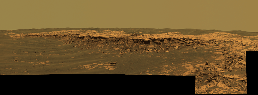
Payson PanoramaThe Opportunity Pancam cameras acquired this panorama of the Payson outcrop on the western edge of Erebus Crater on sol 744 (Feb. 26, 2006). From this vicinity at the northern end of the outcrop, layered rocks are observed in the approximately 1 meter thick vertical extent of the crater wall, in addition to the rocks disrupted by the impact event and subjected to erosion over time. To the left of the outcrop, a flat, thin layer of spherule-rich soils overlays more outcrop materials. The rover is currently traveling down this "road" and observing the approximately 25 meter length of the outcrop prior to departing Erebus crater. The panorama consists of 28 separate images in 4 different Pancam filters, and covers about 90 degrees of terrain around the rover. Two versions are provided at full resolution: an approximate true color rendering using Pancam's 753nm, 535nm, and 432nm filters, and a false color rendering using the same filters, but presented to enhance the subtle color differences between different rock and soil units in the scene. Image-to-image seams have been eliminated from the sky portion of the mosaic to better simulate the vista a person standing on Mars would see.
Jim Bell |
| Full Resolution Images |

|
|
Approximate True Color .jpg .tif Image size: 5295 x 1950 |
|
|
False Color .jpg
.tif Image size: 5295 x 1950 |
|
Image credit: NASA/JPL/USGS/Cornell Image mosaicking: USGS (Jeff Johnson), Cornell (Jonathan Joseph) Calibration and color rendering: CCC and the Pancam team (Jim Bell) |