"Husband Hill Summit Panorama (full)"
This is the Spirit Pancam "Husband Hill Summit"
panorama, acquired on sols 583 to 586 (August 24-27, 2005), shortly after Spirit
completed her climb to the summit of Husband Hill.
This is the largest panorama yet acquired from the Spirit rover. The panorama consists of 653 separate images in 6 different Pancam filters, and covers all of the rover deck and the full 360 degrees of surface rocks and soils that were visible to the Pancams from this position. This is the first time the team has been able to image the entire rover deck and visible surface from the same position. Stitching together of all the images took significant effort because of the large changes in resolution and parallax across the scene.
The image is an approximate true color rendering using Pancam's 750nm, 530nm, and 480nm filters for the surface, and the 600nm, 530nm,and 480nm filters for the rover deck. Image-to-image seams have been eliminated from the sky portion of the mosaic to better simulate the vista a person standing on mars would see.
This panorama provided the team's first view of the "Inner Basin" region (center of the image), including the enigmatic "Home Plate" feature seen from orbital data. Spirit is now driving downhill into the Inner Basin region. Spirit arrived at the summit from the west, along the direction of the rover tracks seen in the middle right of the panorama. The peaks of "McCool Hill" and "Ramon Hill" can be seen on the horizon near the center of the panorama. The summit region itself is a broad, windswept plateau. Spirit spent more than month exploring the summit region, measuring the chemistry and minerology of soils and rocky outcrops at the peak of "Husband Hill" for comparison with similar measurments obtained during the ascent.
Jim Bell
Pancam PEL
29 November 2005
Image credit: NASA/JPL/Cornell
Image mosaicking: JPL/MIPL team (Bob Deen, Kris Capraro, Amy Chen, Jeff Hall, Vadim Klochko)
Calibration and color rendering: Cornell Calibration Crew and the Pancam team (Jim Bell)
Full Size JPG | Full Size TIFF
Image Dimensions: 22348x6547


"Husband Hill Summit Panorama" (polar and vertical projections)
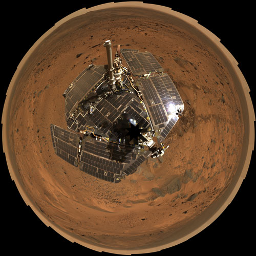
The image on the left is a bird's-eye view that combines a self-portrait of the spacecraft deck and a panoramic mosaic of the Martian surface as viewed by NASA's Mars Exploration Rover Spirit. The rover's solar panels are still gleaming in the sunlight, having acquired only a thin veneer of dust two years after the rover landed and commenced exploring the red planet. Spirit captured this 360-degree panorama on the summit of "Husband Hill" inside Mars' Gusev Crater. During the period from Spirit's Martian days, or sols, 583 to 586 (Aug. 24 to 27, 2005), the rover's panoramic camera acquired the hundreds of individual frames for this largest panorama ever photographed by Spirit
This image is an approximately true-color rendering using the camera's 750-nanometer, 530-nanometer and 480-nanometer filters for the Martian surface, and the 600-nanometer, 530-nanometer, and 480-nanometer filters for the rover deck. This polar projection is a compromise between a cylindrical projection (here as well) which provides the best view of the terrain, and a vertical projection, which provides the best view of the deck but distorts the terrain far from the rover. The view is presented with geometric seam correction.
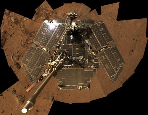
On the right is the most recent self-portrait of NASA's Mars Exploration Rover Spirit, showing the solar panels still gleaming in the Martian sunlight and carrying only a thin veneer of dust two years after the rover landed and began exploring the red planet. Spirit's panoramic camera took this mosaic of images on the 586th sol, or Martian day, of exploration (Aug. 27, 2005), as part of a mammoth undertaking that resulted in the largest panorama (here as well) ever acquired by Spirit. This image is a subset of that panorama, showing just the rover. The vertical projection used here produces the best view of the rover deck itself, though it distorts the ground and antennas somewhat.
This image is an approximate true-color rendering that combines images taken through the camera's 600-nanometer, 530-nanometer and 480-nanometer filters.
Jim Bell
Pancam PEL
01 January 2006
Image credit: NASA/JPL/Cornell
Image mosaicking: JPL/MIPL team (Bob Deen, Kris Capraro, Amy Chen, Jeff Hall, Vadim Klochko)
Calibration and color rendering: Cornell Calibration Crew and the Pancam team (Jim Bell)
Full Size JPG (polar) | Full Size TIFF (polar)
Image Dimensions: 11627x11627
Full Size JPG (vertical) | Full Size TIFF (vertical)
Image Dimensions: 6515x5052
Back to Panoramas


